Jornalismo
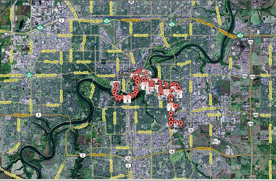 O professor André Lemos, do Programa em Comunicação e Cultura Contemporânea da UFBA, acaba de disponibilizar um dos seus projetos de pós-doutorado em Edmonton, no Canadá. Trata-se do SUR-VIV-ALL um projeto que envolve Google Maps e GPS no mapeamento de hotspots na cidade. Abaixo a descrição do SUR-VIV-ALL:
- Sur-viv-all Em Vídeo
O professor André Lemos, coordenador do GPC, apresenta, em vídeo, todas as fases para a realização do projeto de pós doutorado SUR-VIV-ALL, lançado no final do mês passado. O SUR-VIV-ALL foi baseado no livro Survival [ sobrevivência] de Margaret...
- Bicicleta Detecta Presença De Conexão Wi-fi
O crescimento das redes de internet móvel pelas cidades do mundo tem incentivado a criação de novos mecanismos para detectarem essa conexão. No Canadá, já circula uma bicicleta que alerta o usuário, através de um sinal sonoro, sobre a proximidade...
- Paris Wi-fi
Paris, a cidade das luzes, agora é também uma cidade sem fio. O projeto Paris Wi-Fi, que oferece internet sem fio gratuitamente nos espaços públicos (parques, quiosques, bibliotecas, museus) da cidade, foi lançado ontem pelo prefeito da capital...
- Vídeo Sobre O Projeto Sur-viv-all
O professor André Lemos apresenta, em vídeo, as etapas para construção do projeto SUR-VIV-All lançado na semana passada (ver post) como parte do seu pós-doutorado em Edmonton, no Canadá. O SUR-VIV-ALL foi concebido a partir do livro de Margaret...
- Mapeamento De Hotspots Em Salvador
O Grupo de Pesquisa em Cibercidades do Programa de Pós-Graduação em Comunicação e Cultura Contemporâneas, da UFBA, está fazendo um mapeamento dos hotspots (pontos de acesso sem fio/wireless) em Salvador. O Projeto de mapeamento "Wi-Fi Salvador"...
Jornalismo
Projeto SUR-VIV-ALL
O professor André Lemos, do Programa em Comunicação e Cultura Contemporânea da UFBA, acaba de disponibilizar um dos seus projetos de pós-doutorado em Edmonton, no Canadá. Trata-se do SUR-VIV-ALL um projeto que envolve Google Maps e GPS no mapeamento de hotspots na cidade. Abaixo a descrição do SUR-VIV-ALL:"GPS Writing, SUR-VIV-ALLThe idea came from the crossing of my reading of the book by Margaret Atwood, "Survival," with my research on locative media, city, mobility and new technologies. In the book "Survival", the author defends the thesis that the relationship with the survival is a pattern in the imagination of Canadian literature, both of prose and poetry: fighting the forces of nature, the natives, and the animals. . So, from my research on locative media, I plan to "write" the city of Edmonton (on 40 km) with a GPS Tracker, and mapping some hotspots along the way (using iStumbler, Loki, Google Maps, Google Earth...). For the first GPS draw take a look at Jeremy Wood work. What I was looking for here, in addition to entertainment, was a way to get closer to the city, to understand and feel their spaces, their dynamics. But, basically, a way to see my "survival" here.The word "SURVIVAL" has been changed to "SUR-VIV-ALL," trying to create different meanings in English and French, the official languages Canada, and in Portuguese, my mother language. In French we can see or inferred "SUR VIV (R) E / VIE ...", something like an excess and a lack of life, just when survival is the least and last resort of existence. In Portuguese, "VIVA", claiming to live, an imperative. In English "survival", has its original meaning, plus the "ALL" that calls for a social dimension, the public and community.What is at stake here is the imagination of the city, the relationship with extreme temperatures, the use of cars as standard displacement, the empty spaces, the invisibility of electronic processes (written by the GPS is invisible as well the hotspots Wi - Fi) on the actual structures in the midst of public space. We have photos, videos that attempt to capture this relationship, but with the thread to link with the outside world, the nature. The "Waypoints" on the map will show (as soon as we fished the data transfer) this multimedia content, as well as Wi-Fi hotspots open (we've accessed some networks on the street) or closed."
André Lemos
loading...
- Sur-viv-all Em Vídeo
O professor André Lemos, coordenador do GPC, apresenta, em vídeo, todas as fases para a realização do projeto de pós doutorado SUR-VIV-ALL, lançado no final do mês passado. O SUR-VIV-ALL foi baseado no livro Survival [ sobrevivência] de Margaret...
- Bicicleta Detecta Presença De Conexão Wi-fi
O crescimento das redes de internet móvel pelas cidades do mundo tem incentivado a criação de novos mecanismos para detectarem essa conexão. No Canadá, já circula uma bicicleta que alerta o usuário, através de um sinal sonoro, sobre a proximidade...
- Paris Wi-fi
Paris, a cidade das luzes, agora é também uma cidade sem fio. O projeto Paris Wi-Fi, que oferece internet sem fio gratuitamente nos espaços públicos (parques, quiosques, bibliotecas, museus) da cidade, foi lançado ontem pelo prefeito da capital...
- Vídeo Sobre O Projeto Sur-viv-all
O professor André Lemos apresenta, em vídeo, as etapas para construção do projeto SUR-VIV-All lançado na semana passada (ver post) como parte do seu pós-doutorado em Edmonton, no Canadá. O SUR-VIV-ALL foi concebido a partir do livro de Margaret...
- Mapeamento De Hotspots Em Salvador
O Grupo de Pesquisa em Cibercidades do Programa de Pós-Graduação em Comunicação e Cultura Contemporâneas, da UFBA, está fazendo um mapeamento dos hotspots (pontos de acesso sem fio/wireless) em Salvador. O Projeto de mapeamento "Wi-Fi Salvador"...